- Distance:
- Approx 4¼ miles
- Time required:
- 1½ to 2¼ hours (based on a leisurely 20-30 mins per mile, but you should add on more time if you want to stop at any of the places)
- Starting point:
- Outside Tower Hill station
- End point:
- Museum of London
- What you will see:
- Roman wall, Tower of London, Tower Hill, All Hallows-by-the-Tower, Sky Garden, Leadenhall Market, Lloyds of London, Gherkin, The Monument, Tower Bridge, Mansion House, Royal Exchange, Bank of England, St. Paul’s Cathedral, Temple Bar, St. Mary-le-Bow, Guildhall, Roman amphitheatre (Guildhall Art Gallery), Roman fort
The idea behind this walk is that we are going to be transported back in time to the year 50 AD, when the Romans first came to town and started building the wall. I have tried to include every little brick and piece of mortar that still exists from Roman times and lots of interesting sights and landmarks as well, because no one wants to look at a load of boring bricks all day. So it should be good.
Oh yeah… and before we start I need to tell you something. In order to get the most out of this walk you will need to dress up as a Roman (I’m being serious). So that means hiring a toga and a pair of sandals from the fancy dress shop. If you can get hold of a slave to boss around as well, then that will be perfect. I know that slavery is frowned upon these days, but who cares – let’s do it anyway! It doesn’t do them any harm does it. It’s not like we are going to whip them (that is optional). I am definitely going to whip mine, but I will leave that up to you.
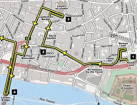
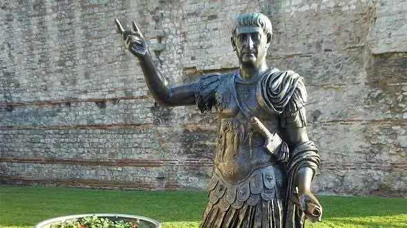
Let’s begin the day outside Tower Hill train station [see 1 on the map]. Right beside the front door is a huge chunk of the city wall that towers eight metres above your head (the roman bit only goes up to the first four metres). They’ve also got a big statue of the Emperor Trajan there pointing to the train station for some reason. Look for the plaque on the wall which provides a little bit of info about how the wall was constructed. It also shows you a map of where the entire wall used to run. Sadly practically all of it has disappeared now apart from this bit, a bit further north, and some big chunks by the Barbican – and we will visit all of them before the day is out.
To get to the next section you need to walk through to the other side of the station and turn right past Trinity Square Gardens. Keep walking for a tiny bit up Trinity Square and Cooper’s Row and keep your eyes open for the Grange City Hotel (it’s only a very short distance). You need to turn right into a courtyard at the Grange City Hotel. If you do it right then get ready to be impressed – this is easily the prettiest piece of wall still standing.
After that we’ll double back and enter Trinity Square Gardens. You get quite a nice view of the Tower of London from here, and if you head over to the far corner and search around for a bit, then you should come across the spot where they killed all of the traitors. This place is called Tower Hill, and you are standing on the exact same spot where they set up the axe and the gallows and thousands of people would gather around shouting and screaming for the drop. There’s a little plaque in the ground that lists all of the traitors’ names – famous names like Thomas Cromwell, Thomas More and the Earl of Essex.
But wait a minute… what has any of this got to do with Roman London? Absolutely nothing! But it’s still interesting nonetheless. But this next bit is definitely worth a look because you’ll get to see your first piece of Roman pavement. Can you see that church across the road with a green steeple? That is All Hallows-by-the-Tower. Have a nose around inside there and find a little flight of stairs at the back. This will take you down into a tiny little crypt. This is probably the last place that you’d expect to see some Roman stuff, but they’ve got a little museum down there with inscriptions and bowls and a big piece of mosaic pavement that is still in situ.
Once you’ve had a good look at that, keep moving down Byward Street, Great Tower Street and Eastcheap. As you walk down the road remember to look left across St. Dunstan’s Hill and St. Mary-at-Hill… because the Shard keeps popping up between the buildings. Turn right into Philpot Lane [see 2 on the map].
It was at this point that I stopped for my first coffee break. I’d only been walking for fifteen minutes but that was enough for me – it was teatime. I’ve got a thing about drinking posh coffees at those high street coffee shops at the moment – the ones that take about ten minutes to brew and end up costing you two weeks wages. There’s a coffee shop on the corner of Philpot Lane if you want to follow in my footsteps. Ask for a medium latte – because that’s what I had. And sit in the seat by the door too, and then you will have exactly the same experience as me. Remember to spill a bit of coffee on the table too, because that’s what I did.
Tea break over, head up Philpot Lane and one of London’s tallest skyscrapers will be towering over your head – the Walkie Scorchie. A few weeks after this was opened it famously started to melt all of the cars in the road below, because the curved glass focused all of the sun’s rays into the street. So if it’s sunny be extremely careful down here – I don’t want you bursting into flames (I won’t be liable for that, by the way, so you can’t sue me). There’s a tropical garden on the 35th floor called the Sky Garden that you can visit for free (as long as you print off a ticket on their website first). If you’re reading this in advance then I definitely recommend giving it a go just for the views alone.
Cross over the road at the end of Philpot Lane and enter Leadenhall Market. If you’ve never seen this place before then you’re in for a treat. It’s an old Victorian market with fantastic ironwork and red and gold gildings.
1,950 years ago we would have been standing right in the middle of the Roman Basilica, but nothing remains of it above ground today. Not unless you include a shop that sells spaghetti.
I’m going to make the route a bit confusing now… but I think you can handle it. One of the cross roads that leads out of Leadenhall Market is called Leadenhall Place. Walk to the end of that road and look left – I absolutely love this view. You are looking at Lloyds of London and the Gherkin [see 3 on the map]. Apparently the Romans were quite fond of eating gherkins, so that does at least have a little connection with Rome. Now walk back inside the market again and head out the opposite way into Gracechurch Street.
Turn left and keep going until you come to another London landmark… The Monument. You should see it’s flaming pot on top of a tall stone column when you get further down the street. Just keep walking until you see it on the left – you can’t miss it. Walk around it (or spend half-an-hour climbing up the 311 steps if you are mad), and then keep going over London Bridge.
We’re not actually going to cross over the whole of the bridge, just halfway, but it’s worth a quick pop down here just for the river views [see 4 on the map]. You’ll see our old friend the Shard again, rising high above the office blocks ahead, and the big battleship HMS Belfast moored in front of Tower Bridge. This is one of the best views of Tower Bridge, but it always seems to be very windy on this stretch of the river which makes your camera shake. This modern-day London Bridge is only about sixty metres away from the original site of the Roman bridge that spanned the Thames in AD 55, so if we were standing here 1,950 years ago then the banks would be full of Italians in togas and metal hats with feathers sticking out the top.
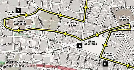
Now double-back the way you came but turn left down Cannon Street. I faced a little bit of a dilemma when I was designing the walk at this point, because no sane person would choose to walk down Cannon Street when King William Street leads to better things. But bear with me… because there is something down Cannon Street that is worth a look.
When you reach Cannon Street station look across to the opposite pavement. There should be a boring-looking grille on the wall [see 5 on the map]. Have a look through that grille and you will see the famous London Stone. Now this might be Roman, or it might not. And it might be medieval, or it might not. Or it might just be a boring lump of rock. Nobody quite knows.
Some people think that it was the stone from which Arthur pulled Excalibur. Other people think that it was the meteor which wiped out the dinosaurs. But whatever it is, it’s on display in Cannon Street.
Now turn right down Walbrook and walk to the end. I took a little detour at this point, but you don’t have to. It’s not part of the walk; but if truth be told I was knackered and I needed a rest. So I popped into St. Stephen Walbrook church and sat down and said a prayer for world peace. It’s quite a unique little church with a big slab of rock in the middle which doubles up as an altar. That’s the great thing about modern art – you don’t have to fork out thousands of pounds for a talented sculptor anymore, because you can just leave it as an unhewn lump of rock.
Back outside… turn right at the end of the street and enjoy one of the finest sights in London. Two of the buildings in this junction wouldn’t look out of place in Imperial Rome – Mansion House and the Royal Exchange. The Exchange could easily be a temple. It’s not though… it’s a shopping centre. You don’t believe me? Have a quick look inside if you’re brave enough (it took me a while to pluck up the courage to walk in there the first time I saw it).
Now head down Queen Victoria Street for some more buried Roman remains – the London Mithraeum (aka. the Temple of Mithras) [see 6 on the map]. The actual statues from the temple (or what’s left of them) are on show at the Museum of London… which is where this walk will come to an end.
Take a right into Watling Street (a good Roman-sounding name), and check out the little Dickensian side streets. Imagine if these places were lit by gas-lamps and dripped in fog. It’s the kind of place where Tiny Tim might come out hobbling on his crutches.
If you’re wondering whether Watling Street follows the line of the original Roman Watling Street, then it doesn’t – but it might be very close. Some archaeologists believe that it ran from Greenwich up to Westminster, bypassing the north bank completely, whilst others insist that it came over London Bridge and continued in a straight line through Bishopsgate. Other experts have picked out a section that runs through Park Lane and the Edgware Road. So they basically haven’t got a clue. But they can all agree that the odds of it running along the same line as the modern day Watling Street is zero.
At the end of Watling Street you’ll find the back end of St. Paul’s Cathedral, so walk through the gardens on the lefthand side until you come round to the front steps. Then stop and say another prayer. I prayed for world peace again, and also for an end to world hunger and a cure for all known diseases. They’ve got a little restaurant and some toilets downstairs, so this is the perfect place for a break. Don’t enter the cathedral through the front door though (that’s the bit you have to pay for) – you’ll find the entrance to the Crypt around the lefthand side if you’re looking at the cathedral from the front [see 7 on the map].
Now walk through St. Paul’s Churchyard (the gardens on the opposite side) until you come to Cheapside, and then check out St. Mary-le-Bow church halfway down. I actually went inside here but you don’t have to (I needed another sit down you see – my dodgy knees were killing me today).
There was a nice smell of incense floating around and the priest was pottering around having a little bit of a tidy up. The place was full of wooden school chairs – what is it with school seats in churches? They’ve even got those in St. Paul’s. It makes me think of being back at school with the teacher at the front. Here’s one famous thing that I can tell you about St. Mary-le-Bow church… you have to be born within the sound of its bells to be a true cockney.
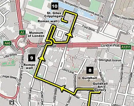
Keep walking down Cheapside and take a left down King Street, and you’ll see the facade of the medieval Guildhall straight ahead, where the Lord Mayor holds all of his City meetings [see 8 on the map].
Next door to the right is the Guildhall Art Gallery. Not very Roman, you might think (it certainly doesn’t look Roman) – but wait! What is that big grey ring of bricks that I spy on the forecourt? Well, that is none other than the original site of London’s Roman amphitheatre! How about that then? You weren’t expecting that, were you? So if we were standing here 1,950 years ago we could have enjoyed one of those Christians v The Lions sports shows. Personally I would have put my money on the lions every time. And what is even more exciting is that you can actually visit the Roman remains in the basement of the art gallery – it is totally free to enter, so there really is no excuse not to go and have a look – it’s probably the highlight of this Roman walk.
The tour gets a lot more interesting from this point on, because there are some really big pieces of Roman masonry coming up. Take a stroll up Gresham Street and bear round to the right at Noble Street. If we travelled back in time then we would now be entering the southern section of the Roman fort (which was located in the northwest corner of the city). Down the side of the street you’ll see what remains of the outer wall [see 9 on the map].
Unfortunately it doesn’t look very old anymore because it’s all been built over with bricks, but the foundations are still big and rocky like you would expect them to be. I think the Germans bombed this bit of London in the 1940s, and uncovered a lot of what you can see. So that is something that we can thank Hitler for at least – at least he did a bit of archaeology for us.
Carry on walking over the busy main road (called London Wall – where the northern edge of the city once ran) and you’ll see a little curved road down to a car-park – it’s slightly to the right of Noble Street, and heads downwards towards the left. Head down there and you will see some more wall that rises to quite a height. This time it’s a curved section that once formed part of a bastion tower. You are allowed to walk over the grass and follow it up the western edge of the fort – those offices on the right are where the barracks would have been. The wall carries on for quite a distance, and when you get to the end you’ll be treated to a nice little surprise – it opens out into a big pool of water, complete with another corner turret. It’s almost like a moat around the fort. You won’t be able to get any further unfortunately because there’s a big green gate that bars your way (unless you’ve bought some dynamite with you), so double back the way you came and head up the car park ramp to the road again.
This time we’ll take the stairs that you can see to the left. I don’t mean the concrete ones to the right – they are definitely on the left as you come up the ramp, and it should be signposted ‘Barbican Centre’ and ‘Museum of London via Highwalks’. We want the Barbican Highwalk.
Now be careful around here, because it’s notoriously easy to get lost in this place – if you don’t lose your way at least once then you will be doing very well indeed. It’s like a big concrete maze of high walks that goes up and down and round and round in circles. Someone actually got lost in here once and staggered out five years later. They had to send a search party in, which also got lost. Then they sent Ranulph Fiennes in, and he got lost as well. That is how easy it is to get lost in here. So you might want to take a packed-lunch and some bottled water with you, just in case.
Once you are on the highwalk turn to the left and keep going past the little parade of shops. Then turn left into ‘The Postern’. Resist the temptation to go down ‘Wallside’, and keep going until you come to the stairs near the end of The Postern (on the left). This will take you down to the ground level again, and plop you right in front of St. Giles Cripplegate church [see 10 on the map]. If you do a lap of the church then you will see the other side of that circular tower that we saw earlier, standing proud beside the moat. There is also another huge chunk of Roman wall along the water’s edge – the final section on our walk.
All that remains now is for you to find your way back, and not get lost. Can you remember the way back? If you can’t then that’s unlucky because I can’t be bothered to give you directions, ha ha. You should have dropped some breadcrumbs! Now you are going to be stuck in here for days and will probably die of hunger. Ah well. (I am not liable for that, by the way. So you can’t sue me.) I will keep an eye out for you the next time I visit… which will probably be in about six months.
If you manage to re-pass that little parade of shops then there is just one more thing to do… don’t go down the starting stairs again, but carry on in a straight line towards the Museum of London. If you’re not totally knackered from all the walking then it’s worth looking inside the museum to see all of the Roman remains they’ve got on display (including that Temple of Mithras stuff that we saw earlier). It’s all free and what’s even better… they’ve got a cafe and some toilets too!
Your comments and questions
M&L Thank you for this very interesting walk. We will have to visit London again as we got caught up in interesting bits and distractions along the way, and ran out of time just at the best part at Noble Street. Thanks, again, from Ottawa, Canada.
Maggie Your site is THE BEST about London! I have been to MANY site & yours is the most thorough & interesting. It is a ONE STOP SHOPPING site for anyone who wants to visit London! Thanks, Maggie in Ohio, USA
Leave a comment