- Distance:
- Approx 4¼ miles
- Time required:
- 1½ to 2¼ hours (based on a leisurely 20-30 mins per mile, but you should add on more time if you want to stop at any of the places)
- Starting point:
- One New Change
- End point:
- Parliament Square
- What you will see:
- St. Paul’s Cathedral, Temple Bar, St. Bride’s, St. Dunstan’s, Sweeney Todd’s barbershop, Temple Church, Royal Courts of Justice, Covent Garden, Nelson’s Column, Trafalgar Square, National Gallery, Leicester Square, Piccadilly Circus, Admiralty Arch, Horse Guards, Banqueting House, Downing Street, The Cenotaph, Houses of Parliament
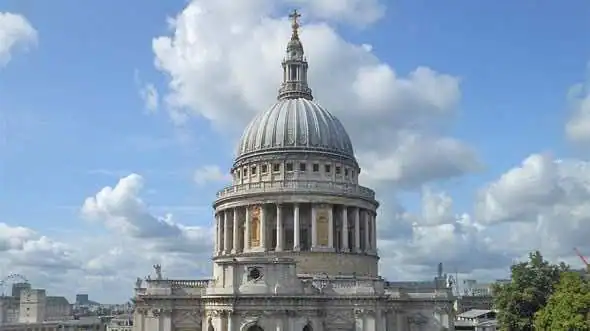
We’re going to start this walk by standing still for ten minutes at the top of One New Change. That’s the shopping centre around the back of St. Paul’s Cathedral. It sounds rubbish, but trust me, this is the best shopping centre in London because they’ve got a viewing platform on the roof… so I thought we’d go up there and see our walk stretched out before us. It’s totally free so you don’t have to worry about the cost – just ride the central lift all the way to the top and step out into the sky.
You’ll have to move around the deck a bit to see all of the sights, but you can see straight past the righthand side of St. Paul’s down Fleet Street to the Royal Courts of Justice (look for big clock hanging off the wall past St. Dunstan’s), then – if you shift around a bit more – then you can the make out the Victoria Embankment by Hungerford Bridge. Behind that big white building with the lime green roof (visible directly above Hungerford Bridge) is Whitehall.
Carry on looking to the left past the London Eye and you can just about see the top of the Victoria Tower too, which is at the far end of Parliament. The only piece of Big Ben that is visible is the very tip of the spire in front of the London Eye.
So that’s our walk! We’re going to set off in a minute and have a walk all the way round to Big Ben. And because you know where everything is now, you shouldn’t get lost.
It’s a tough choice deciding which way to walk around St. Paul’s. The righthand side is definitely prettier because you can walk straight through the churchyard, but I think that you get better photos of the dome around the lefthand side. I suppose you could walk around the whole lot if you are feeling super fit. If you want to start your day with a cup of tea then try the righthand side first, because there is a doorway down into the cathedral crypt where you can have a cup of coffee.
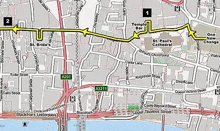
While you’re here remember to have a quick nose into Paternoster Square on the right… especially that stone archway leading in [see 1 on the map]. That is called Temple Bar, and you need to remember what it looks like (because we’re going to see another picture of it later). This archway used to stand halfway up Fleet Street and marked the limits of the City’s authority. It looked a lot more lively back in those days because they stuck a couple of poles on top with the heads of traitors on, but they don’t allow that anymore (shame).
Okay… let’s head down Ludgate Hill and get going towards Big Ben, otherwise we’ll never make it before midnight. There’s nothing much to see in Ludgate Hill itself so just keep going until you get to Fleet Street. After you’ve crossed the busy junction you should be able to see the spire of St. Dunstan’s in the distance – that church we saw from the top of One New Change. I love this old church and it’s worth a quick look inside.
There’s one more church before we get there that I recommend too – St. Brides, which is hidden in a little courtyard on the left. No one is ever home when I visit these churches, just maybe an old cleaner pottering around dusting the flowers, and a tired homeless guy asking God what he’s done wrong.
Fleet Street used to be home to all the national newspapers and it was buzzing with the sound of printing presses all through the night. But these days it’s full of sandwich shops after they followed Murdoch to Wapping in the 1980s. There’s a couple of old newspaper HQs worth seeing (like the Art Deco headquarters of the Daily Express), but the best of Fleet Street belongs in the past.
Check out the Ye Olde Cheshire Cheese pub, which dates all the way back to the Great Fire of London (an even earlier version of it got burnt down) [see 2 on the map]. Samuel Johnson is supposed to have drunk in here (and got drunk in here) because his house is just around the corner in Gough Square. It’s one of the dingiest pubs in London with black wooden beams and sawdust on the floor… but be careful of the low ceilings because I cracked my head on an archway once and it hurt like hell.
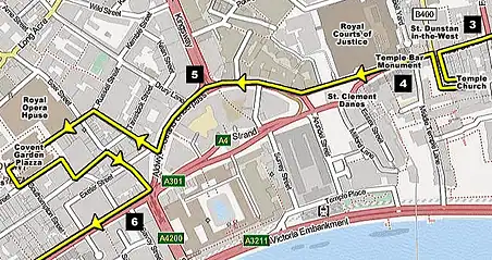
Before we get to St. Dunstan’s check out the building next door (with ‘People’s Friend’ written on it). That block is the traditional site of Sweeney Todd’s barbershop… the one where he slit his victims’ throats and sent them plummeting into the tunnels below [see 3 on the map]. Legend has it that they were linked to the catacombs next door, where he cut them up and sold the meat to Mrs Miggins. Believe it or not this story seems to have some truth to it, because there really was a criminal called Sweeney Todd in Fleet Street. But all the rest is codswallop.
Now step inside St. Dunstan’s… This church contains my favourite piece of religious furniture in the whole of London, and if the Great Fire of London started up again then this is the one thing that I would save. Have you ever tried to describe a beautiful face? I mean… enough to make people agree without seeing it? It’s practically impossible. You can say she’s got blonde hair and blue eyes but you might be describing Margaret Thatcher for all they know. So I won’t try and describe the wooden scene inside – just do yourself a favour and go and have a look.
We’re going to take a little detour now… Just past St. Dunstan’s on the other side of the road is a big black wooden arch. Head through there and down the alley and you’ll find Temple Church. This is the place made famous by the Knights Templar and, more recently, Dan Brown in his Da Vinci Code book. You have to pay a few quid to get inside unfortunately, but it’s worth a quick look just to see the sleeping knights on the floor. Even if you don’t want to go inside then it’s still definitely worth a look at the exterior.
Now return to Fleet Street and stop at that tall monument in the centre of the road. How’s your memory? Because this is the Temple Bar Monument, and marks the exact spot where that gate used to stand that we saw in Paternoster Square [see 4 on the map]. How fantastic would it be if it were still standing there now? Unfortunately nothing is allowed to halt the pace of the buses and cars, and the Victorians tore it down to improve the traffic flow. If you look at the carvings on the side then you can see what it used to look like when it was still in situ.
After that comes the Royal Courts of Justice. We’ve got the Victorians to thank for this beauty. You can actually have a nose around inside for free if you don’t mind braving the security. They’ll give you a proper pat down and send you through some x-ray scanners, so don’t bother if you’ve bought your machine gun along (it will get confiscated), but it’s worth a go just to see the vast cathedral-like interior. This is where they do all of the celebrity divorce cases, so if you hang around long enough then maybe you’ll see some smiling women bounding out.
Now you need to pass St. Clement Danes and head down Aldwych (don’t go down the lefthand side because that’s boring – go down the right) [see 5 on the map]. After you pass the Waldorf Hilton Hotel you need to turn right up Catherine Street and then left at the end, where you’ll see the Covent Garden piazza straight ahead.
I could give you a route through Covent Garden but you’ll probably just prefer to have a nose around by yourself. You definitely want to see inside the piazza and overlook the balcony to the bit downstairs. That’s where they usually have a few classical buskers playing Vivaldi and Mozart, and you can have a sit down and a coffee. If you are gasping for a pint then there’s a pub at the far end called the Punch & Judy with a balcony overlooking the square (it’s usually packed). You’ll find some more street entertainment in the square outside St. Paul’s (the church, not the cathedral!). If you’re going to stop for a spot of lunch then Covent Garden is the perfect place to do it. When you’re ready find Wellington Street and head back out to the Strand [see 6 on the map].
The Strand isn’t one of my favourite roads in London, but short of getting a bus it’s the only way down to Trafalgar Square. But you can have a look at the Savoy as you go, and watch Nelson’s head getting bigger as he sits above the rooftops. As you pass by Charing Cross station on the left make a mental note of that tall pointy monument in the car park, because I’ll be saying some more about that later.
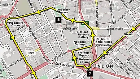
Welcome to Trafalgar Square! Let’s get our bearings… can you see that big archway straight ahead? That’s called Admiralty Arch and it’s the ceremonial entrance to the Mall. If you carry on walking down there for five minutes (which we’re not) then you’d end up at Buckingham Palace. We’re going to go up the stairs by the National Gallery instead, and rest our elbows on the balcony. This will give you the best view of the fountains, and also give you your first view of Big Ben in the distance.
If you want to have another coffee then try the Caffe Nero or Pret A Manger on the corner, or you can pop into the National Gallery or St. Martin’s church.
When you’re ready to continue have a stroll over to statue at the top end of Whitehall, and I don’t mean Nelson’s Column… I mean that equestrian statue standing fifty feet in front, on that little traffic island. That is King Charles I, one of our most useless monarchs [see 7 on the map]. He’s guy that Oliver Cromwell beheaded after the English Civil War (you probably didn’t recognise him with his head on). I’ll be saying a bit more about this doofus when we reach his execution site, so for now I will just give you a few little nuggets about the traffic island… Did you know that you are standing at the very centre of London? – This is where they traditionally measure all of the distances from; from the base of the King Charles statue. But that’s not the best thing about it… do you remember that big pointy monument we just saw standing outside Charing Cross station? Well, that is a Victorian marker for the medieval Eleanor Cross, which used to stand on this very spot.
When Edward I’s queen died in 1290 he was so upset that he had them parade her coffin all the way down from Lincoln to Westminster Abbey, and every time the procession stopped for a rest he’d put up an elaborate cross. So that’s what the ‘cross’ in Charing Cross actually is – the last resting spot before her coffin reached the Abbey. (This area used to called be the hamlet of Charing, before it got swallowed up by Westminster.) Unfortunately the original cross has long since disappeared, so all we’ve got left is the name and that Victorian marker in the train station car park.
Before we head off down Whitehall towards Big Ben we’re just going to do a little detour around Leicester Square and Piccadilly Circus (they’re not very far), so head round the back of the National and past the National Portrait Gallery until you reach Irving Street on the left. This will take you into Leicester Square – one of my favourite places. That big TKTS booth straight ahead is where people buy all of the cheapo last-minute theatre tickets [see 8 on the map].
Head straight through the middle of the square and bear left at the M&Ms shop (it sounds daft but yes, there really is a whole shop devoted to M&Ms). A quick walk down there, past the impressive horse fountain on the corner, and you’ll end up underneath the neon lights at Piccadilly Circus.
The two roads straight ahead are Piccadilly (another one of my favourite roads) and the curved facade of Regent Street. We’re going to head down Regent Street – but not that bit. Regent Street actually continues down the left at right angles to it. You’ll probably need to look at the map to work it out, because it really is silly. Or just look for the road with a big column at the end. And what’s that big tower you can see in the far distance? …it’s the Houses of Parliament again! This is the third time that we’ve caught sight of it on this walk, and we still haven’t got within half-a-mile of it.
The section at the end of this road is called Waterloo Place, and it probably has the best collection of statues in London [see 9 on the map]. It’s also where you’ll find all of the Gentlemen’s Clubs – that cream and blue one on the corner is the famous Athenaeum. You’ll find the Traveller’s Club and Reform Club down Pall Mall on the right – where Phileas Fogg set out on his journey around the world.
When I was younger I always used to mix up this big column at the top with Nelson’s Column, and I’d come down here from Piccadilly Circus thinking that I’d end up in Trafalgar Square (what can I say… I was an idiot!). But it’s actually called the Duke of York’s Column – the same guy as in the nursery rhyme who marched his men to the top of the hill, and then marched them down again. And here he is… standing at the top of his hill. But there’s no sign of his ten thousand men though. Just you and me and a few tourists sitting on the steps eating their sandwiches.
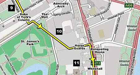
Go down the steps and look towards the right. That’s Buckingham Palace down there, but we’re going to turn left and follow the bend in front of Admiralty Arch until we come to Horse Guards Parade. Can you see the yellow parade ground in the distance? What a view!
As you walk down there check out that ivy-covered brown building to the left [see 10 on the map]. The reason they’ve covered it all over in ivy is because it’s so damn ugly… but they had to erect it quickly during World War II to give them somewhere safe to plot their battles. It’s called the Citadel, and rumour has it that there are tunnels underneath that stretch all the way from Downing Street to Buckingham Palace. As you pass into the parade ground look up at the top right corner and you will see the windows where the gun emplacements would have been, had the Germans ever made it this far.
The building next door is the Old Admiralty Building, where the Navy bigwigs used to have their offices… in the days when our navy still had some boats. These days they’ve all been shifted over to the Ministry of Defence, but the government has still jealously kept hold of the building so we can’t go inside.
Now look across to the opposite side of the parade ground, at that brown brick wall that runs along the edge [see 11 on the map]. You can probably see a couple of machine-gun coppers standing nearby. That’s because on the other side of that wall is the garden of No.10 Downing Street.
Let’s just stand in the parade ground for a while and take a few photos. I love the way the London Eye peeps over the top.
When you’re ready head straight through the centre of Horse Guards (there is a little archway in the middle) and you’ll find yourself by the horse boxes on Whitehall.
Directly over the road from those is Banqueting House. This is where we meet Charles I again, because it was on this very spot that they chopped off his head. They didn’t do it in the building though – they erected a big wooden platform in the street and did it in front of a huge crowd of Londoners. Charles was allowed an hour to compose himself and gather his thoughts inside Banqueting House before stepping out of a door about halfway up the wall. You can’t see any trace of the door anymore unfortunately, but if you look where the entrance is today, then imagine a door on the first floor in the brown wall to the right. If you enter the building then you will see a big staircase behind it – that’s where Charlie took his final bow: out of that wall and onto the stage.
If you look back over the road to Horse Guards then you will see a clock on top of the tower. Can you see a little dark mark behind the number two? That’s not a speck of dirt – they deliberately put that there to mark the hour that Charlie’s clock stopped ticking.
Further down Whitehall is Downing Street. It wasn’t so long ago that you could actually walk down the street itself, but the IRA put paid to that in the 1990s with all their mortar bombs and shootings, and Maggie Thatcher thought it prudent to stick a big barricade across the end. So all you can do nowadays is stand outside the gate and peer over the shoulders of a big burly gun cop. What you are looking for is a big black door on the right, about halfway up the street. Number 10 is the one with an ornamental arch over the top, with a lamplight hanging in the middle. It’s not the best view in the world (you are looking at it from a very shallow angle) but it’s definitely visible. If the Prime Minister came out then you would easily see him. If you are prepared to wait around long enough then you might even see them open the gate to allow the limo out.
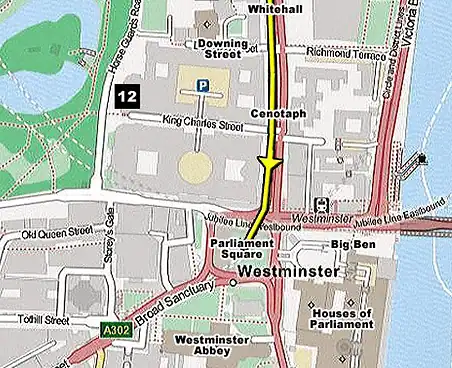
Carry on walking past that big monument in the centre of the road. That’s the Cenotaph, which honours the dead from all our wars (and we’ve had a lot of wars). Just past that on the right is the entrance to King Charles Street. The Foreign Office and Treasury buildings are situated on either side, so they always have a lot of barricades and security guards hanging around the entrance, but you are definitely allowed to walk down that street because the Churchill War Rooms are at the very end [see 12 on the map]. It’s definitely worth a look because they film a lot of period dramas down there because the street looks so grand. I saw a load of stage coaches and men in top hats and tails down there once… it was like I had entered a time bubble back to Edwardian times.
After that comes Parliament Square and Big Ben. There are lots of things worth seeing around here but you’re probably half-dead by now – I know I am! You can carry on looking around the Houses of Parliament and Westminster Abbey if you have enough energy.
Your comments and questions
Be the first to talk about this walk
Leave a comment